


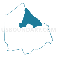
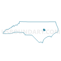
Voting District CAST, Greene County, North Carolina
About
Outline

Summary
| Unique Area Identifier | 640196 |
| Name | Voting District CAST |
| County | Greene County |
| State | North Carolina |
| Area (square miles) | 35.26 |
| Land Area (square miles) | 35.25 |
| Water Area (square miles) | 0.02 |
| % of Land Area | 99.95 |
| % of Water Area | 0.05 |
| Latitude of the Internal Point | 35.55179610 |
| Longtitude of the Internal Point | -77.62194320 |
Maps

Graphs
Select a template below for downloading or customizing gragh for Voting District CAST, Greene County, North Carolina


Neighbors
Neighoring Voting District (by Name) Neighboring Voting District on the Map
- Voting District 0800A, Pitt County, NC
- Voting District 0800B, Pitt County, NC
- Voting District BEAR, Greene County, NC
- Voting District MAUR, Greene County, NC
- Voting District WALS, Greene County, NC
Top 10 Neighboring County Subdivision (by Population) Neighboring County Subdivision on the Map
- Farmville township, Pitt County, NC (6,703)
- Olds township, Greene County, NC (3,990)
- Speights Bridge township, Greene County, NC (2,085)
- Ormonds township, Greene County, NC (1,980)
- Carrs township, Greene County, NC (839)
Top 10 Neighboring Unified School District (by Population) Neighboring Unified School District on the Map
Top 10 Neighboring State Legislative District Lower Chamber (by Population) Neighboring State Legislative District Lower Chamber on the Map
Top 10 Neighboring State Legislative District Upper Chamber (by Population) Neighboring State Legislative District Upper Chamber on the Map
Top 10 Neighboring 111th Congressional District (by Population) Neighboring 111th Congressional District on the Map
Top 10 Neighboring Census Tract (by Population) Neighboring Census Tract on the Map
- Census Tract 18, Pitt County, NC (6,120)
- Census Tract 9501.02, Greene County, NC (5,260)
- Census Tract 9501.01, Greene County, NC (4,018)
- Census Tract 19, Pitt County, NC (2,889)